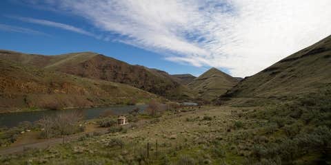
Twenty miles of gravel road leads to Macks Canyon Recreation Site, positioned at the end of the Lower Deschutes Access Road where the canyon opens to the river. This BLM campground sits along the Deschutes River with 18 sites accommodating everything from tent campers to big rigs, though the washboard access road tests both vehicles and patience.
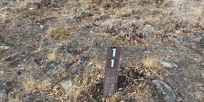
The campground stretches along the riverbank where campers watch fishing boats and rafts drift past during the day. A railroad track runs across the water, adding periodic train traffic to the canyon sounds. Site 11 offers direct river access according to recent visitors. Wind picks up predictably in the evening hours, typically lasting about an hour before calming. No cell service reaches the canyon, though satellite internet works for those who need connectivity.
James W. notes the campground stays "clean, and hardly anyone here" with often just one or two sites occupied out of 18 available. The rough access road requires slow speeds for the final six to seven miles, though most vehicles manage the route with care. From the road's end above the campground, hikers can follow the old railway line for canyon views. Other campgrounds along the access route include Rattlesnake Canyon and Beavertail Campground — Lower Deschutes Wild And Scenic River.
This spot works best for campers who prioritize solitude and river access over easy road conditions.
Description
The Macks Canyon archaeological site is a large, prehistoric village locale overlooking the Deschutes River in north-central Oregon. The site is characterized by shallow, circular, semi-subterranean house depressions, surface artifacts, and riverine shell deposits. Limited excavations conducted in the late 1960's indicate that the site was the location of a winter village occupied by Sahaptin-speaking people of the Columbia Plateau. Although the main period of occupation appears to have occurred within the last 2,000 years, the site may have been occupied as early as 5,000 BC. A campground and boat ramp are situated at the end of the Access Road along the east bank of the Lower Deschutes River. The area is popular with boaters and fishermen. The route to Macks Canyon is also a National Back Country Byway. ADA Access: The archaeological site itself does not have accessible facilities. However, the nearby campground has an accessible campsite, vault toilets and parking.
Fee Info
No fees at the archeological site. Camping: $8.00/night fee applies Sunday through Thursday nights, Friday and Saturday night fee is $12.00/night, Group Sites are $25.00/night Sunday through Thursday nights, Friday and Saturday night fee is $35.00/night. May 15th September 15th. There is a $2.00 charge per extra vehicle (tow vehicles excluded).
Reservation Info
First come, first serve
RV Road Trip Guides

Location
Public CampgroundMacks Canyon Recreation Site is located in Oregon
Directions
From Maupin City Park in Maupin, Oregon, proceed a short distance north to the junction of Bakeoven Road and the BLM Access Road.Turn left onto BLM Access Road and drive 7.0 miles.Continue onto Deschutes River Road for one mile. Turn right onto OR-216 E (signs for Grass Valley) and proceed for 0.5 mile. Turn left onto BLM Access Road and drive 17.4 miles to the road’s end.
Coordinates
45.3913277 N
120.8787514 W
Connectivity
 T-MobileNo Coverage
- VerizonNo Coverage
- AT&TNo Coverage
Connectivity
- T-MobileNo Coverage
- VerizonNo Coverage
- AT&TNo Coverage
Access
- Drive-InPark next to your site
Site Types
- Tent Sites
- Group
- Tent Cabin
Features
For Campers
- Trash
- Picnic Table
- Reservable
- Toilets
- Alcohol
- Pets
- Fires
For Vehicles
- Pull-Through Sites
- Big Rig Friendly
Drive Time
- 3 hrs 16 min from Bend, OR
- 3 hrs 24 min from Portland, OR
- 3 hrs 30 min from Yakima, WA
- 3 hrs 32 min from Kennewick, WA


