Hikers exploring ancient Puebloan ruins can access Bandelier National Monument's cliff dwellings directly from Juniper Family Campground via a 1.5-mile trail to the visitor center. The campground sits on a mesa above Frijoles Canyon, offering 93 sites across three loops with varying terrain and tree coverage.
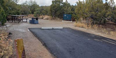
The Abert's Squirrel and Black Bear loops feature open sites among juniper and pinyon pines, while the Coyote loop provides more shade under tall ponderosa pines. Jean C. notes that "sites are sunny and open with scrub trees providing an element of privacy between sites." Most sites accommodate smaller RVs and tents, though only a handful can handle rigs over 30 feet. The campground includes recently paved parking pads, bear boxes, picnic tables, and fire rings.
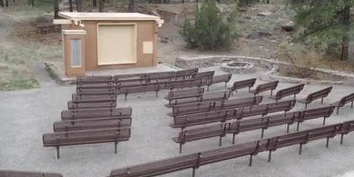
Water spigots and flush toilets with sinks are available throughout, but there are no showers or hookups. A dump station operates near the entrance, though it closes during winter months. Robin T. describes the atmosphere as "very quiet and peaceful" with "most of the campsites nicely spread out and lots of trees." The seasonal amphitheater hosts ranger programs when staffing allows.
Access requires navigating Highway 4, which several reviewers describe as rough and washboard-like in sections. The campground operates on a first-come, first-served basis except for group sites, with self-pay stations accepting credit cards only. During peak season, shuttles transport visitors to the main archaeological sites, though the hiking trail from camp remains open year-round.
Winter visitors should prepare for snow and cold temperatures at this high-elevation location. For additional camping options, see campgrounds around Bandelier National Monument.
Description
Overview
Juniper Family Campground is the ideal place to camp on the Pajarito Plateau. Located just inside the main park entrance, the campground is a short drive from the Bandelier Visitor Center, the Frijoles Canyon Shuttle bus system (mid-May to mid-October), and the adjacent towns of Los Alamos and White Rock. Juniper Family Campground is the perfect "home base" to explore the Pajarito Plateau, Jemez Mountains, and all of north central New Mexico! The campground is divided into 3 loops: Abert's Squirrel Loop (Loop A) campsites are available year-round as first-come, first serve only. Pay for first-come, first-serve campsites at the self-pay kiosk located at the Juniper Family Campground or in-person at the Bandelier Visitor Center during business hours. Black Bear Loop (Loop B) campsites are open year-round and are reservable up to 6 months in advance. Some sites may open on shorter booking windows (7 or 14 days in advance or the day of arrival). Coyote Loop (Loop C) campsites are open seasonally, March 1 October 31, and are reservable up to 6 months in advance. Some sites may open on shorter booking windows (7 or 14 days in advance). You may also book campsite reservations in Loops B & C on the day of arrival (subject to availability). HOWEVER, cell service/data is not always reliable in the park and no public WiFi is available. The park highly recommends booking your reservation from the neighboring towns of Los Alamos and White Rock before heading to Bandelier. Group campsites (in Loop A) are available by reservation only up to 12 months in advance until the day before arrival (subject to availability). Same day reservations are not available for group campsites.
Recreation
Bandelier is home to over 70 miles (113 km) of hiking trails most of which are located within federally designated wilderness. Two trails are accessible directly from Juniper Family Campground. The Frey Trail follows the historic route into Frijoles Canyon and descends down the canyon wall to the Visitor Center and the Main Loop Trail. The Tyuonyi Overlook Trail leaves the amphitheater parking area for a 3/4-mile (1.2 km) hike across the open mesa top to an overlook providing breathtaking views of Frijoles Canyon and of Tyounyi, an ancestral Pueblo village. The Bandelier Visitor Center houses museum exhibits, park film, information and ranger programs, Western National Parks Association sales outlet, and more. Entrance to Frijoles Canyon and the Visitor Center is by shuttle bus only (or by hiking) from mid-May to mid-October. These areas are accesibile by private vehicle outside the shuttle bus period. Many other opportunities for recreation and exploring the history and culture of the area are nearby, such as Valles Caldera National Preserve, Manhattan Project National Historical Park, Los Alamos museums, the Jemez District of the Santa Fe National Forest, US Department of Energy public recreation trails, and others around Los Alamos County. Rock climbing is prohibited within Bandelier National Monument, however many popular climbs are within a short drive up Route 4 into the Jemez Mountains.
Facilities
Juniper Family Campground has 3 camping loops. There is an RV dump station on the road into the campground, however water at the dump station is completely turned off from mid-October to mid-April (campers will not be able to fill water tanks or dump). RV dump station has been turned off for season (11/10/25). During the summer months, interpretive programs may be offered during the day at the Visitor Center and in the evening at the campground amphitheater (check with the Visitor Center for program schedule)._Each loop offers its own comfort station with restrooms and running water and centrally located water spigots with potable water. No hookups are available at any campsites. Shade is limited in most campsites. During the summer months a camp host is present in the campground._Individual CampsitesEach individual campsite has a paved parking pull in or pull through parking spot. Driveways/pull through size vary by site, many can accommodate larger RVs/trailers. Picnic tables, fire rings with grills, and food lockers are provided at each campsite. There are three camping loops with individual campsites:Group CampsitesGroup campsites Each group campsite is for tent camping only and has ample space for multiple tents. Only one (1) RV or trailer is permitted per site. Each site can accommodate 10 to 20 campers. Group campsites have picnic tables, fire rings with grills and food lockers._TransportationThe Frijoles Canyon Shuttle system (mid-May to mid-October) includes a stop at the Amphitheater parking area located in the Juniper Family Campground. You may ride the shuttle free of charge with service into Frijoles Canyon with a stop at the Visitor Center. Private vehicle traffic into Frijoles Canyon is prohibited while the shuttle is in service.
Natural Features
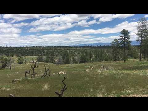
Bandelier National Monument protects over 33,000 acres (13355 ha) of rugged, beautiful canyon and mesa country which features evidence of human presence going back over 11,000 years. Petroglyphs, dwellings carved into the soft rock cliffs, and standing masonry walls pay tribute to the early days of a culture that still survives in the surrounding communities. Bandelier National Monument sits at the southern end of the Pajarito (Spanish for little bird) Plateau. The plateau was formed by two eruptions 1.6 and 1.4 million years ago. Home to the Bandelier Wilderness, Bandelier ranges from 5340 ft (1628 m) at the Rio Grande River to the south and 10,199 ft (3109 m) at the summit of Cerro Grande to the north, almost a mile of elevation change in just under 12 miles (19 km). This elevation gradient creates a unique diversity of habitats specific to Northern New Mexico. The diversity of habitats and quick access to water supported a relatively large population of Ancestral Pueblo people. Currently, Pi__on-Juniper woodlands dominate in the southern parts of the park transitioning through ponderosa pine savannahs and forests, finally reaching mixed conifer forests at the highest elevation. Scattered throughout the park are desert grasslands, montane meadows, and riparian areas in the canyon bottoms. Over 70 miles (113 km) of trails at Bandelier climb in and out of deep canyons and cross large flat mesas, showcasing the entire spectrum of volcanic geology and ecosystems found within the park. The park is home to over 55 species of mammals including mule deer, Abert's squirrels, mountain lions, black bears, and 16 species of bats. Reptiles and amphibians of all shapes and sizes can be seen. Birds such as Steller's jays, canyon towhees and mountain chickadees stay year-round, whereas turkey vultures, western tanagers, and black-headed grosbeaks are summer residents.
Contact Info
This location is unstaffed. To speak with our main office for general information, please call: (505) 672-3861.
Nearby Attractions
The town of Los Alamos has shopping, museums, amenities, a movie theater, ice rink, ski hill, and is home to Manhattan Project National Historic Site. Nearby Department of Energy and US Forest Service lands provide trails which accommodate pets. Valles Caldera National Preserve is 16 miles (26 km) west of Bandelier. Jemez Historic Site is 37 miles (60 km) west. Pecos National Historical Park is 70 miles (113 km) southeast. Santa Fe, 40 miles (64 km) south of the park, is home to the New Mexico state capitol, museums, historic districts, art galleries, food, accomodations, and more.
Fee Info
Camping Fees. Payment for reservations is due upon booking. You may pay for first-come, first-serve campsites (Abert's Squirrel Loop) at the self-pay kiosk in the campground or in-person at the Bandelier Visitor Center during business hours. Entrance fees. Bandelier National Monument charges an entrance fee separate from camping fees. The park's entrance station is staffed most days during business hours. If unstaffed, you may pay the fee upon arrival at the automated fee machine at the Bandelier entrance station, at the Bandelier Visitor Center during business hours or purchase in advance. The park also honors Federal interagency passes (e.g., annual, senior, access, 4th grade, Golden Age pass etc.). For more information visit the park's Fees & Passes web page. Entrance passes or Federal Interagency Passes must be displayed in all vehicles while in the park. Non-commercial group (scouts, church group, etc.) entrance fees, visit: Non-Commercial Groups at Bandelier Commercial group entrance fees, visit: Commercial Tours at Bandelier
RV Road Trip Guides


Location
Public CampgroundJuniper Family Campground — Bandelier National Monument is located in New Mexico
Directions
From Santa Fe (approximately 1 hour travel time): Take Highway 84/285 (Saint Francis Drive) north toward Los Alamos. Merge right onto NM 502 to Los Alamos. Exit onto NM 4 toward White Rock. Continue for 12 miles (19 km), passing through White Rock. Bandelier's entrance is on the left. Entrance station is staffed most days during business hours. If unstaffed, pay entrance fee using Automated Fee Machine or display America the Beutiful pass on vehicle dashboard. Continue 3 miles to visitor center if you have questions about park fees/passes. Turn right onto Campground Rd. For those with reservations, proceed directly to campsite. No check-in needed. For those looking ofr first-come, first serve campsites, Abert's Squirrel Loop (Loop A) is the first right. Find an open site, then return to campground kiosk to pay camping fee at Automated Fee Machine. From Taos (approximately 1.5 hours travel time): Take NM 68 (Paseo del Pueblo Sur) south. In Espanola, turn right onto Fairway. Turn left on Highway 84/285. Turn right on NM 30. Merge right onto NM 502 to Los Alamos. Exit onto NM 4 toward White Rock. Continue for 12 miles (19 km), passing through White Rock. Bandelier's entrance is on the left. Entrance station is staffed most days during business hours. If unstaffed, pay entrance fee using Automated Fee Machine or display America the Beutiful pass on vehicle dashboard. Continue 3 miles to visitor center if you have questions about park fees/passes. Turn right onto Campground Rd For those with reservations, proceed directly to campsite. No check-in needed. For those looking for first-come, first serve campsites, Abert's Squirrel Loop (Loop A) is the first right. Find an open site, then return to campground kiosk to pay camping fee at Automated Fee Machine. Visit the Directions page on the park website for detailed directions from other areas.
Address
15 Entrance Road
Los alamos, NM 87544
Coordinates
35.7961111 N
106.2791667 W
Connectivity
 T-Mobile5GExcellent CoverageVerified by 39 usersLast on 4/1/26
 VerizonLTESome CoverageVerified by 9 usersLast on 4/1/26
 AT&TLTEGood CoverageVerified by 14 usersLast on 4/1/26
Connectivity
- T-Mobile5GExcellent CoverageVerified by 39 usersLast on 4/1/26
- VerizonLTESome CoverageVerified by 9 usersLast on 4/1/26
- AT&TLTEGood CoverageVerified by 14 usersLast on 4/1/26
Access
- Drive-InPark next to your site
- Walk-InPark in a lot, walk to your site.
Site Types
- Tent Sites
- RV Sites
- Standard (Tent/RV)
- Group
Features
For Campers
- Trash
- Firewood Available
- Phone Service
- Reservable
- Drinking Water
- Toilets
- Alcohol
- Pets
- Fires
For Vehicles
- Sanitary Dump
- Water Hookups
- Pull-Through Sites
- Big Rig Friendly
Drive Time
- 46 min from Santa Fe, NM
- 1 hr 35 min from Albuquerque, NM
- 3 hrs 19 min from Farmington, NM
- 4 hrs 8 min from Pueblo, CO