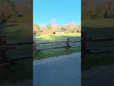
Horse enthusiasts find direct access to equestrian trails at this walk-in campground within Boise National Forest. The site accommodates various camping styles across a large area with both covered spots under trees and more open areas for different preferences. Campers reach the grounds via a dirt road off Highway 21, positioned far enough from the main route to minimize road noise during overnight stays.
The forested setting includes proximity to water features and provides picnic tables and restroom facilities. Winter visitors use the area for snowshoeing when snow conditions allow. For additional options in the region, campers can explore sites near Boise National Forest. The walk-in access and equestrian focus make this campground well-suited to horse campers and those seeking a less vehicle-dependent camping experience.
Description
Overview: Whoop-um-up Equestrian Campground is located 56 miles northeast of Boise, Idaho, along State Highway 21, under a scenic pine forested canopy. There are six campsites complete with feed boxes, hitching posts and water for stock. Wildlife and summer wildflowers are abundant. The historic town of Idaho City is just 11 miles south. The Crooked River runs near the site, offering rainbow trout fishing. Natural Features: State Highway 21, also known as the Ponderosa Pine Scenic Byway, snakes along Mores Creek to Mores Creek Summit, Gold Fork, and Banner Ridge with breathtaking views of the surrounding mountains and forest. The Crooked River runs near the campground offering an opportunity to catch a rainbow trout. Recreation: Numerous trail opportunities are in the area, offering hiking, biking and horseback riding. In winter, the area becomes a playground for backcountry skiers and snowmobilers.
RV Road Trip Guides

Location
Public CampgroundWhoop-Em-Up Equestrian Campground is located in Idaho
Directions
<p>From Idaho City, Idaho, travel north along State Highway 21 about 17 miles to the campground.</p><p>You will pass Mores Creek Summit. </p><p>The entrance is on the east side of State Highway 21.</p>
Coordinates
43.96267322 N
115.62960575 W
Connectivity
 T-MobileNo Coverage
- VerizonNo Coverage
- AT&TNo Coverage
Connectivity
- T-MobileNo Coverage
- VerizonNo Coverage
- AT&TNo Coverage
Access
- Walk-InPark in a lot, walk to your site.
Site Types
- Tent Sites
- RV Sites
- Standard (Tent/RV)
- Group
- Equestrian
Features
For Campers
- Trash
- Picnic Table
- Toilets
- Alcohol
Drive Time
- 1 hr 6 min from Boise, ID
- 2 hrs 41 min from Twin Falls, ID
- 4 hrs from Pocatello, ID
- 5 hrs from Lewiston, ID