Housatonic Meadows State Park Campground is located near Sharon, CT, featuring a landscape of forests and the Housatonic River. Temperatures range from 20°F in winter to 85°F in summer. Nearby attractions include the Appalachian Trail and Kent Falls State Park.
Description
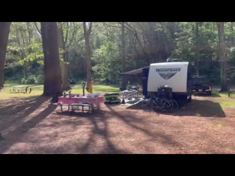
Located in the rock-strewn valley of the Housatonic River, amid the rugged hills of the northwestern uplands, Housatonic Meadows is an ideal setting for a variety of outdoor recreational activities. Camping under the tall pines on the riverbank gives the overnight visitor a genuine back-to-nature feeling. The clear, cold river water also provides a fine opportunity for fly fishermen to test their skills on trout and bass. A two-mile stretch of river, including the park shore, is limited to fly fishing.
Campground Rules & Information
Campground Rules & Information
ALCOHOL IS PROHIBITED AT THIS CAMPGROUND
PETS ARE PROHIBITED AT THIS CAMPGROUND
Primary Occupant Requirements
- Must be present to check in and register for the campsite.
- Must be 18 years of age or older (21 for cabins).
- Must present valid government-issued photo identification.
- Must provide valid vehicle registration and, if necessary, the camper registration (confirmation email).
- Must list the first and last names of the camping party, as only the listed names are allowed to occupy the campsite.
Check-In / Check-Out Times
- Cabins: Check-in begins at 2:00 PM. Check-out time is 11:00 AM.
- Campsites: Check-in begins at 1:00 PM. Check-out time is 12:00 noon.
- All campers, for both campsites and cabins, must check in by 10:00 PM.
- The camp office closes at 8:00 PM from Sunday through Thursday. If arriving after this time, please contact the office in advance.
- A $50 refundable security deposit is required at check-in for all cabin rentals, payable by cash or check only.
Visitors
Visitors may enter state campgrounds from 8:00 AM to sunset and may stay until 10:00 PM. Daily parking rates may apply.
Firewood Policy
To protect Connecticut’s forests from destructive insect pests, bringing firewood into state campgrounds and parks from other states is strictly prohibited. Firewood can be purchased locally.
Length of Stay
The maximum stay is 14 consecutive days. After a 14-day reservation, all members of your camping party and equipment must leave the park for five days before returning.
Reservation & Cancellation Policy
When making a reservation, you must agree to the cancellation and refund policies. Customers are responsible for reviewing site amenities and campground policies before booking.
Refunds will not be issued for:
- Accidental bookings.
- Failure to confirm site details or amenities.
- Failure to read or follow campground policies.
- No-shows, early departures, or shortened stays.
- Cancellations made within two days of the scheduled arrival.
Wildlife Precautions
- Black bears, deer, skunks, raccoons, and other wildlife share this space with you.
- Store all food, hygiene items, and trash in appropriate containers or inside your vehicle.
Fireworks Policy
Fireworks of any kind, including sparklers, are strictly prohibited in Connecticut State Parks and Forests.
Warning 1 Alert is In Effect
There is 1 alert for this campground. Camp safely!
Warning 1 Alert is In Effect
There is 1 alert for this campground. Camp safely!
You can now make a reservation for the day before your arrival and up until 11 months in advance. For campsites, (excluding cabins) if you make your reservation within 3 days of your arrival you can book a 1 night stay. The maximum length of stay is fourteen consecutive days. if you have a 14 day reservation, all members of your camping party and your camping equipment must leave the park for 5 days before you can return. Any reservation with a departure date that is more than 11 months from today cannot be changed or cancelled for 18 days after the reservation was made for an inland campground and 25 days for sites at Hammonasset and Rocky Neck.
Location
Public CampgroundHousatonic Meadows State Park Campground is located in Connecticut
Directions
From the north/Great Barrington/Pittsfield, MA: Travel south on Route 7 into Sharon, CT. The park is located along Route 7 in the Town of Sharon, approximately 3 miles south of the West Cornwall Covered Bridge, and approximately 2 miles north of the intersection with Route 4. From the south/Greater Danbury: Travel north on Route 7 into Sharon, CT. The park is located along Route 7, approximately 2 miles north of the intersection with Route 4, and approximately 3 miles south of the West Cornwall Covered Bridge. From the east/Hartford: Travel west on I-84, and take Exit 39. Continue west on Route 4. From Cornwall Bridge (after crossing the Housatonic River), turn north on Route 7. The park is located in Sharon, CT, along Route 7, approximately 2 miles north of the intersection with Route 4.
Address
US ROUTE 7
Sharon, CT 06069
Coordinates
41.83824346 N
73.38006197 W
Connectivity
 T-MobileNo Coverage
- VerizonNo CoverageLast on 7/23/25
- AT&TNo Coverage
Connectivity
- T-MobileNo Coverage
- VerizonNo CoverageLast on 7/23/25
- AT&TNo Coverage
Access
- Drive-InPark next to your site
- Walk-InPark in a lot, walk to your site.
- Boat-InSites accessible by watercraft.
Site Types
- Tent Sites
- RV Sites
- Cabins
Features
For Campers
- Firewood Available
- Reservable
- Showers
- Drinking Water
- Electric Hookups
- Toilets
- Pets
- Fires
For Vehicles
- Sanitary Dump
- Sewer Hookups
- Water Hookups
- Pull-Through Sites
- 30 Amp Hookups
- 50 Amp Hookups
Drive Time
- 44 min from Waterbury, CT
- 1 hr 1 min from Hartford, CT
- 1 hr 3 min from Pittsfield, MA
- 1 hr 6 min from Kingston, NY