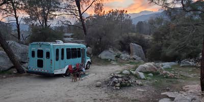
Wind patterns along the Kern River create steady breezes that keep the air moving at this BLM-managed site just outside Lake Isabella. Keysville South Recreation Site spreads across both sides of the river, with a designated group area on one bank and dispersed camping spots scattered on the opposite side.
Full hookups serve RVs on the developed side, while tent campers and self-contained rigs can claim riverside spots among the dispersed sites. The rough access road challenges low-clearance vehicles but remains passable for most rigs. Dumpsters and vault toilets appear on both sides of the water crossing. Connor N. notes the site is "conveniently located only a couple miles outside of town" with reliable Verizon coverage throughout the area.
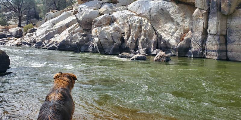
Fishing access draws anglers to the river's edge, while hiking trails branch into the surrounding hills. The dispersed sites show wear from heavy use, though the riverside location provides direct water access for those willing to navigate the uneven terrain. Day visitors often arrive for rafting launches, creating midday activity along the water.
Security concerns surface in reviews, with one camper reporting theft while away from their site. Those planning extended day trips away from camp should secure valuables or consider staying closer to the developed area where other campers provide natural oversight.
Description
Keysville (formerly Keyesville) is a historic mining area that offers a wide variety of recreational opportunities. Set in rolling terrain amidst a blue oak and foothill pine woodland, Keysville is dissected by the lower Kern River. A little exploration can turn up a wealth of historic resources, including a variety of mining structures and features, a historic fort, and the famous Walker Cabin. Keysville offers commercial and noncommercial white-water rafting opportunities as well as fishing, recreational gold panning, and dispersed camping. A network of over seventy miles of trails provides for mountain biking, equestrian, and motorized recreation use.
All motorized use is limited to designated roads and trails. For a map of Keysville area designated routes, see https://www.blm.gov/documents/california/public-room/map/keysville-recreation-management-area.
RV Road Trip Guides


Location
Public CampgroundKeysville South Recreation Site is located in California
Directions
From the junction of CA-178 and CA-155 at the town of Lake Isabella, take exit 155 onto CA-155. Keysville South entrance (for camping and river access) is approximately 0.6 miles from this junction on the left (west) side of the road befpor crossing the Kern River. Keysville North entrance (for camping, OHV, and other trail use) is on the left another 0.4 miles down highway 155, just past the bridge across the Kern River.
Coordinates
35.6355725 N
118.48411955 W
Connectivity
 T-Mobile5GExcellent CoverageVerified by 21 usersLast on 4/3/26
 VerizonLTEGood CoverageVerified by 12 usersLast on 4/3/26
- AT&T5GExcellent CoverageVerified by 12 usersLast on 4/3/26
Connectivity
- T-Mobile5GExcellent CoverageVerified by 21 usersLast on 4/3/26
- VerizonLTEGood CoverageVerified by 12 usersLast on 4/3/26
- AT&T5GExcellent CoverageVerified by 12 usersLast on 4/3/26
Access
- Drive-InPark next to your site
- Walk-InPark in a lot, walk to your site.
- Boat-InSites accessible by watercraft.
Site Types
- Tent Sites
- RV Sites
- Standard (Tent/RV)
- Dispersed
- Group
- Equestrian
Features
For Campers
- Market
- ADA Access
- Firewood Available
- Reservable
- WiFi
- Showers
- Drinking Water
- Electric Hookups
- Fires
For Vehicles
- Sanitary Dump
- Sewer Hookups
- Water Hookups
Drive Time
- 49 min from Bakersfield, CA
- 1 hr 47 min from Visalia, CA
- 1 hr 55 min from Hanford, CA
- 2 hrs 17 min from Fresno, CA


